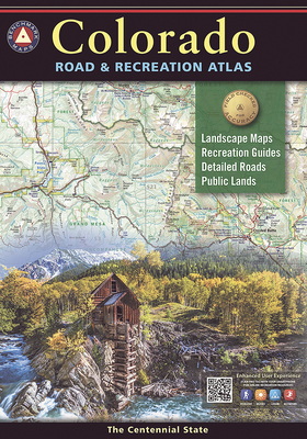
Benchmark's Colorado Road & Recreation Atlas is designed to help residents and visitors make the most of Colorado's endless recreation opportunities. The recreation guide includes lists of attractions, trailheads, fishing spots, historic sites, and much more throughout the state. The Landscape Maps show all drivable roads, classed by surface and purpose. Large-scale metro maps of Denver, Boulder, and Colorado Springs are also included.
Read More
Benchmark's Colorado Road & Recreation Atlas is designed to help residents and visitors make the most of Colorado's endless recreation opportunities. The recreation guide includes lists of attractions, trailheads, fishing spots, historic sites, and much more throughout the state. The Landscape Maps show all drivable roads, classed by surface and purpose. Large-scale metro maps of Denver, Boulder, and Colorado Springs are also included.
Read Less
Add this copy of Colorado Road & Recreation Atlas (Benchmark Recreation to cart. $21.70, fair condition, Sold by Dream Books Co. rated 5.0 out of 5 stars, ships from Denver, CO, UNITED STATES, published 2019 by Benchmark Maps.
Choose your shipping method in Checkout. Costs may vary based on destination.
Seller's Description:
Fair. This copy has clearly been enjoyed-expect noticeable shelf wear and some minor creases to the cover. Binding is strong and all pages are legible. May contain previous library markings or stamps.
Add this copy of Colorado Road & Recreation Atlas (Benchmark Recreation to cart. $35.95, new condition, Sold by Russell Books rated 4.0 out of 5 stars, ships from Victoria, BC, CANADA, published 2019 by Benchmark Maps.
Add this copy of Colorado Road & Recreation Atlas (Benchmark Recreation to cart. $33.95, new condition, Sold by Wide World Maps & More rated 3.0 out of 5 stars, ships from Phoenix, AZ, UNITED STATES, published 2019 by Benchmark Maps.
Choose your shipping method in Checkout. Costs may vary based on destination.
Seller's Description:
New. Fully revised Landscape Maps that now feature: Over 2, 300 miles newly field-checked, reaching 29 Counties and all national parks & forests, resulting in 400+ edits to recreation & camping POI. Landscape Maps now include GMU boundaries National Forest private in-holdings are shown Ground cover or vegetation as the base layer, rather than elevation-based color. This brings the Colorado atlas in "base carto" alignment with several titles Benchmark has done this to in recent years with positive feedback and increased sales. New overlay for BLM (yellow) and State (blue) lands, a big plus for hunters. Hundreds of edits to road detail & condition and POI data, For example, this was the first atlas to correctly show Browns Canyon National Monument Recreation Guide Public Lands maps are completely updated with point-to-point mileages and attractions. Recreation Guide fact-checked & updated Parks, Monuments, Natural Wonders Campgrounds & RV Parks Boating & Fishing Access Forest & Wildlife Areas Mountain Recreation guide shows all of Colorado's 14ers and ski areas. Benchmark Colorado Road & Recreation Atlas is designed to help residents and visitors make the most of Colorado's endless recreation opportunities. The recreation guide includes lists of attractions, trailheads, fishing spots, historic sites, and much more throughout the state. The Landscape Maps show all drivable roads, classed by surface and purpose. Large-scale metro maps of Denver, Boulder, and Colorado Springs are also included. Dimensions: 16 inches × 11 inches.144 pagesMap Scales: Landscape 1: 200, 000 Recreation 1: 500, 000.